
The summer of 2017 was hot, windy, and dry. Add a lightning strike and a 300-year-old spruce forest to the mix, and you’ve got fire.

Adventures from Arizona to Alberta
The summer of 2017 was hot, windy, and dry. Add a lightning strike and a 300-year-old spruce forest to the mix, and you’ve got fire.
sually, when the word sightseeing is used, I’ll turn and run the other way. I know, it’s my problem, but I can’t help thinking of everything associated with it—as in tourists, crowds, lines, etc. So naturally, Dave and I were skeptical of the Banff Sunshine Sightseeing Gondola from the get-go.
This iconic mountain has an illustrious past that hails back to the mining days of the late 1800s. As the story goes, in 1896, a cook for the Canadian Pacific Railway was bet fifty bucks that he could not summit the Beehive in less than ten hours. He was to plant a flag at the top as proof of his effort. Evidently, they didn’t know how capable Ha Ling was. He left at 7am that Saturday and was back in time for lunch.
In the mid-1980s, Canmore was a sleepy little mountain town in the midst of recreating itself, following the closure of its last remaining coal mine. It was an exciting time. However, it was rumored that the action of one unnamed Canmorite would forever change the landscape of this small town.
The Three Sisters are synonymous with Canmore. Originally named The Three Nuns in 1883, it has been said that George Stewart (the first superintendent of the Rocky Mountains National Park) named the peaks after his three daughters, Frances, Olive, and Grace. The Stoney Nakoda also views these peaks as the three sisters, referring to the story of Ĩ-ktomnĩ, an old man who would promise his three sisters in marriage whenever he got into trouble.
We often share hiking stories with our neighbors, Kirstie, and Kevin. Really, the best way to know what you are getting into is to talk to someone who has done it. And recommends it. This was the case with Healy Pass in Banff National Park.
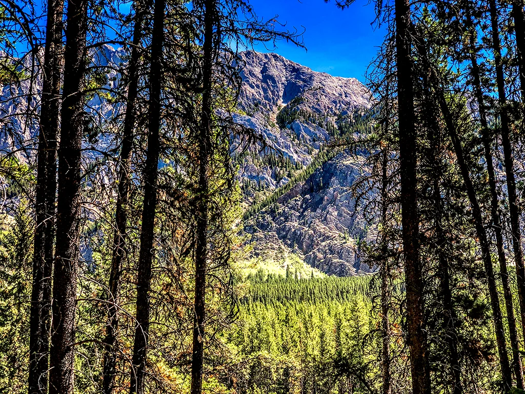
This is our summer of Kananaskis. We have intentionally avoided the hotspots in Banff National Park to focus on hikes that are much less crowded and every bit as beautiful. Our travel time is a bit longer but well worth the effort.
Dave and I love the Dorrien Smith/Spray Lake Trail. We love to take our friends up the narrow, unpaved road, through all its twists, turns, and drop-offs—just to scare the crap out of them. You can always tell if someone has been there by their white, dust-encrusted vehicle. A right of passage, at least until the next rain.
This was our second attempt to hike Ptarmigan Cirque and I am thankful to report that this time, there was very little snow to contend with. After a cold, wet and rainy June, summer decided to finally appear for more than a day or two. The sun finally came out, and so did the people.
Headwall Lake is usually a forgotten hike. It shares the parking lot with the premier Chester Lake trail and doesn’t get star billing. In fact, it gets no billing. Push those thoughts aside—this 10-mile hike weaves through multiple terrain, on its way up to some pretty spectacular views.
Our reason behind hiking Taylor Lake was simple. There was a connection. You see, Dave’s Mom’s maiden name was Taylor. The name alone rekindled wonderful memories for him—even before our hike began.
Canada Day in Canmore is a joyous event. Every year, the town swells from 14,000 to well over 20,000. On July 1st, families crowd the streets to view marching bands, campy floats, olympic athletes on ski-skates and Calgary Stampede dignitaries. Squirt guns are almost mandatory. This year, we decided to change it up.
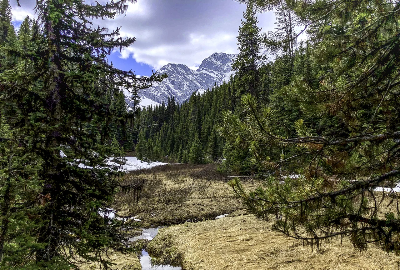
This year, the longest day was truly the longest day. Summer solstice sans summer. But the week of rain and high country snow eventually gave way to sunshine. And, the remaining stretch of Highway 40 in Kananaskis had opened, providing us with the opportunity to hike Ptarmigan Cirque.
It was spur of the moment. Dave and I hastily made a couple sandwiches, threw the bear spray in the Jeep and headed out. Little did we know what we would actually find.

On our way to the cirque!

After a beautiful start up the mountain, we climbed into some thick clouds still remaining from the previous day’s rain. Fog as thick as peanut butter (hahahaha)—made it necessary to turn on fog lights and slow to a snail’s pace. What began as patchy snow became a blanket, reminiscent of early fall in the Rockies.


And then the sun broke through.

Just outside the parking lot at Ptarmigan Cirque Trail.
By the time we reached the cirque, it became apparent that there was to be no hiking today. The snow was close to a foot deep, and our boots were not waterproof.

Fresh snowfall.

You know, all in all, It didn't seem to matter. I had never seen the upper portion of the Kananaskis trail and it was quite magical.

Ptarmigan Cirque can wait. :)
Opportunities are like sunrises. If you wait too long, you miss them.—William Arthur Ward
Our reason for hiking the Grassi Lakes circuit was two-fold. A family of owls was known to be nesting in the cliffs above the lake and it was a beautiful day. With that in mind, Dave loaded up his camera gear and we set off on a photo safari.

Lower Grassi Lake
If there is one hike that appeals to all ages and levels of endurance, Grassi Lakes is it. The trail is about 2.7 miles roundtrip and offers an easy path (service road) and a not so easy path (along the edge) to the top. The lakes, waterfalls and a nearby mountain was named after Italian immigrant Lawrence Grassi—a miner, hiker, climber and master trail-builder. The trail was built by Grassi back in 1918, during a miner’s strike. He went on to build the Oesa trail at Lake O’Hara along with many others. A solitary man, he lived in an ivy-covered cabin by the Grassi trailhead, until his move to Bow Valley Regional Housing, where he lived to the ripe old age of 90.

Lower Grassi Lake.

As with most hikes around here, It pays to be early. We had both lakes mostly to ourselves for at least 45 minutes.

Lower Grassi Lake.
This hike never gets old. Reflections and jewel-like hues were magnified by the early morning light. The clarity was amazing. So much color in such an attainable venue—I can see why Grassi loved it so.

Upper Grassi Lake, looking for owls.

Nothing here but rocks…..
We headed to the upper lake was where the owls nest was located—a craggy cave nestled a steep rock face. Dave swiftly set up the camera and try-pod. He zoomed in and….NOTHING. Wait, wasn’t that the owl on the side of the cave? Nope, it was a ROCK. Dang. Our neighbors had seen them the week before, but for us, it was not to be.

We shrugged it off and continued down the mountain on the cliff side. This was Grassi’s original trail, consisting of steep stairways, flowing creeks, large smooth boulders and spectacular views..


We crept out on a narrow pathway off the main trail to get a closer look of the falls. So worth it.

We may have missed the owls that day, but that only gives us another reason to return.

Homeward bound.
“We love the things we love for what they are.” ― Robert Frost
Sometimes a hike is just a long walk in the woods. Many hikers tend to pass on hikes that don’t reward them with wide open spaces, memorable vistas and physical challenges. I get that. But sometimes, the solitude and quiet of a less travelled path can be quite lovely.

Pocaterra Trail was one of those paths. The trail is a gentle upward climb through the woods, with glimpses of creeks, small lakes and mountains.

Pocaterra Creek.
We were completely alone that morning. The forest floor was damp and soft from the recent snow. Our first detour was to Pocaterra Creek, which we accessed following a game trail. Still in search of that elusive moose…

A sea of fern appeared, captured in early morning sunlight. Another brief scramble took us down to Rockwall lake, it’s muddy bottom covered with elk tracks.

Rockwall Lake.

As we climbed up the ridge, the mountains came into view; below us, lush green meadows.

The trail was wide enough to walk side by side, and easy enough to hold a conversation. Dave and I solved many of the world’s problems that day (hahahaha).
At one point we went off trail in search of Sparrow’s Lake. After foraging uphill through a mass of deadwood and moss we came upon a small meadow. A quick look at the map indicated that we would have to cross multiple ridges to get to the lake. That was not gonna happen. There was no real access from our route.

Strange and creepy mushrooms.
Oh—lest I forget, we saw some pretty weird mushrooms along the way, popping up under pine needles. I do not believe they are edible.
We were about three and half miles in when we realized our sandwiches were still on the counter at home. It was definitely time to head back.
Our favorite trails will open soon. The quiet and solitude will soon be replaced by an onslaught of tourists. But for a brief moment in early June, a quiet walk in the woods gave us both time to just be.
I wouldn’t call Jura Creek a hike—I’d call it an adventure. Located by the Baymag plant on Highway 1A, the trailhead is far from ostentatious. In fact, it’s practically non-existent—the official site is currently under construction. That aside, Dave and I were pleasantly surprised. The real fun began about a quarter mile in at the mouth of the slot canyon.

The mouth of the canyon
This hike was more like an obstacle course through flowing water—consisting of scaling boulders, crossing deep pools on single logs and stepping cautiously from rock to rock. About a mile in, it became apparent to Dave and I that dry feet were not gonna happen.


A smooth piece of Jasper in the creek.
Jura creek was robust, thanks to recent snowmelt. We made our way through a maze of deep, narrow passageways, filled with pools and mini waterfalls. The high walls were cold and damp with sunlight just starting to find it’s way through the opening. Exquisite.
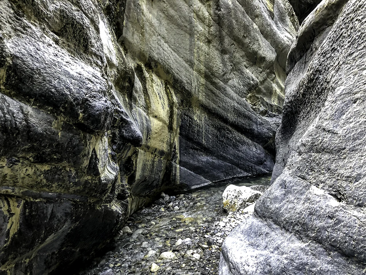

The canyon opened up into a large, rocky creek bed. As we progressed, the creek dried up and the hiking became a little tedious. It did however, give us plenty of time for our feet to dry.

Canyon’s end, nearing the creek bed.
Eventually, we came upon a huge headwall. Dave and I looked at each other, both wondering if we should try to scale it. Hmmm. On the right, super smooth stone that was pretty vertical. To the left, a wall of rock with a v-like formation. A stream of water was flowing down the center. Others have done this—right? Don’t we want to see what’s up there? What the heck. We chose the V.

To the top of the headwall.
In hindsight, it looked a lot harder to climb than it actually was. At the top were a series of pools captured in smooth white stone. We gazed down into deep crevices where the creek graced us with it’s reappearance.


Peering into the cracks.
The trail turned into a creek bed once more. For us, it was the perfect turn-around point. Our return trip was not nearly as graceful. I guess it never really is. We sloshed back through the running creek with reckless abandon, the canyon then filled with sunlight and warmth.
Jura Creek is a well-hidden gem. Selfishly, we both kinda hope it stays that way.
Well, our first couple of weeks in Canmore have been interesting. Any schedule that previously existed was promptly thrown out the window. Especially at night. Luci took a few days to adjust to her new surroundings, and Dota is still adjusting to her new sister. It might take years. Everything around here happens at warp speed—until it doesn’t. Luci reminds me of the Honeybadger, a former LSU and Arizona Cardinal cornerback. She will knock off anything that gets in her way. She actually bounces. All kidding aside, Lucia is a welcome addition.

Sunday morning - before the hike.
With that said, Dave and I left the pups and ventured out for our first hike last week. Elk Pass to Frozen Lake is an 8.4 mile out and back trail located by Lower Kananaskis Lake. The trail, an old fire road, eventually leads to Elk Lakes Cabin (maintained by the Alpine Club of Canada) and a backcountry campground.

It was about an hours drive from our place to the trailhead. The weather was cloudy and a chilly 45°. Our trek started off blissfully snow-free and dry. However, as we gained elevation, the dry trail turned to ice and snow—slowing our pace considerably.

What happened to the trail?

Fox Creek. No sign of moose.
We crossed multiple bridges, following some giant moose tracks in hopes of a sighting.

The Kananaskis range is daunting and massive. There were some impressive views to be had along the way.
Icy meadow. No sign of moose.
As the day progressed, the snow turned into slush. By the time we reached the meadow, it was a real mud-fest. We were about 3.5 miles in when we decided to have a bite to eat and head back.

Wildflowers blooming out of the bog.
Tired and cold, we were still content. For the first hike of the season, it was a splendid way to get our feet (soaking) wet.
It’s time for change. Familiar places, new beginnings. Our May departure crept up quickly. No matter what happens, this summer is going to be different.

On the road with Dota.
It was time. Dota loved being our one and only, but with that came the anxiety of being alone. A new italian greyhound pup was in the works for October, but fate managed to get in the way. We received a email in April from Stephanie and Avery Mcleod of Alfheim Hounds to let us know that a little blue and white pup was available. Oh, and that she was just what we were hoping for.
Wait…should we take a 14-week-old puppy to Canada for the summer?

Lucia
Note to self, if you are not sure, DO NOT LOOK AT THE PHOTO. Nearly impossible to do, I know. Everyone loves a puppy, especially if she is the perfect match. Who could refuse? Not us. So, we took a 1,000 mile detour to Clearview, WA to pick up Lucia (a.k.a. Luci), the newest addition to our canine family.

Somewhere in western Idaho.

Sprague, Washington
Three 12-hour days of driving. Along the way we saw elk, antelope, a coyote, and a couple of black bears. Luci joined Dota for the final day of our journey. They were real troopers. That in itself was amazing. We arrived in Canmore by mid-afternoon, exhausted, but no worse for wear.

Almost there! East Kootenay, B.C.
It is still cold and rainy/snowy here, with the prospect of better weather in early June. When the sun did come out, Dave and I took advantage of it with a hike into town. There is still snow on the ground in some areas and ice in the river.

Bow River, with Cascade Mountain in the background.

Neighborhood elk.
We also managed to take a small hike near Barrier Lake, and drive down Spray Lake Road to check things out. A lot of the trails here do not open until mid to late June.

Barrier Lake.

Barrier Lake, Kananaskis.

Spray Lake.
But signs of spring’s emergence are everywhere and rainfall really is a good thing.

One week in and no complaints. Dota has tolerated Luci quite well. In fact, she has become a bit of a pup herself, much to our chagrin. But, as in the weather, the promise of better days to come is always with us.
Let the adventure begin!
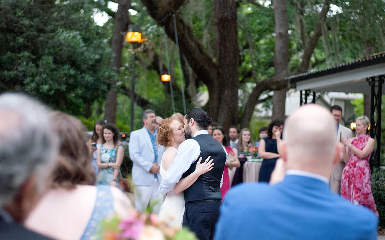
After a year of planning, imagining and anticipation, the big day was finally upon us. Family from across the U.S., Peru and as far as Spain, gathered in Tallahassee to celebrate the wedding of Hillary and Bruno.

Dorothy B. Oven Park was the idyllic setting, and miraculously, the weather was perfect—lush, green and tropical.


Hillary with her beautiful bridesmaids. Photo courtesy of Lizzie Robilliard
Bruno’s mom Ada and I spent the morning with the bride and bridesmaids, along with some very talented hair and makeup artists. I can attest that for me, they were miracle workers. But it wasn’t until I crept downstairs to sneak a peek at the progress, that the enormity of the event finally hit me. My only daughter was getting married. Wow.

Shortly after starting graduate school at FSU, Hillary met the love of her life—Bruno Chiurliza. And it seemed that Dave and I were about to become part of a much bigger picture, full of love and adventure.


So this is really about family, love and celebration. A snippet that we hope captures the wedding’s true essence. A most splendid garden party.


Hats off, and many thanks to Emily Chandler of Poppie Studios, for the gorgeous wedding photography and to Amy Forman of Papaya Wedding Planning, our talented, meticulous and epic wedding planner. And especially, to all of our family and friends who helped make the celebration so memorable.


April in Tallahassee is pretty, pretty nice. The mornings are cool and damp and the real heat hasn’t quite settled in yet. A great month for a wedding—Hillary’s and Bruno’s that is. Dave and I arrived early in the week, to spend some time with our only daughter and future son-in-law. Time to chill a bit before the big day—and help put the couple at ease (or at least try to!).

Lizzie, Oscar and Dave ham it up before class.
Our first couple of days were well spent. We explored FSU, attended one of Hillary’s Abnormal Psych lectures (eye-opening), drank Lucky Goat Coffee (so GOOD) and visited Proof Brewing Co.

St Marks Lighthouse
However, by third day, Dave and I decided it might be helpful if we disappeared for a bit. So we made the short 16-mile drive to St. Marks National Wildlife Refuge for a visit.
This refuge was established in 1931 and is one of the oldest in the National Refuge system. It’s initial purpose was to provide a winter home for migratory birds. It encompasses over 70,000 acres, and 43 miles of gulf shoreline. Our plan was to visit the lighthouse, followed by a five mile walk along some of the salt marshes and bayous in search of wildlife.

I’m not gonna stop him…
On the way to St. Marks Lighthouse, Dave saw a rather large gator lounging in the middle of a sandy road. We parked and crept towards him (not too close) to take a photo. He wasn't interested in us, it was the warmth of the early morning sun he was after. It still freaked me out. Later, Hillary told us the way to get away from an alligator is to run in a zig-zagging motion. It seems that an alligator can only move forward, not diagonally. Good to know.

Southern Bald Eagle
Within minutes we spotted a bald eagle sitting stoically in the pines. Would have been a good time to have a zoom lens—which we did not have.

Dave on the shore.
The lighthouse and path along the shoreline was rugged and full of life. Hundreds of tiny crabs scattered in all directions with every footstep. The beach was narrow and overlooked a large bay. To the south, nothing but ocean, its immensity giving us both an overwhelming feeling of insignificance.

We headed back to the Stoney Bayou pools in search of alligators and a lone pink flamingo, which had relocated in the marsh, following Hurricane Michael. The pathway ran along dikes built between man-made pools, once used for sea salt production during the Civil War. Eagles, osprey, and waterfowl were abundant.

Dave, where did you put the zoom lens????
We did end up seeing the lone pink flamingo (definitely a Where’s Waldo moment), along with at least seven alligators. Not bad for a day in the swamp.

Good news! The bug spray we purchased at the visitor’s center was very effective. Unfortunately, it‘s oiliness combined with abundant sunshine turned us both a lovely shade of red. Undaunted, we capped the day with another visit to Proof for some EightFive-O and talked about the crazy, joyous days to come.
It was the perfect way to unwind prior to the big wind-up.


