Sparrowhawk Tarns

Comment

Sparrowhawk Tarns

At times, selective memory can come in handy. In hindsight, we, as humans, tend to block out certain realities while focusing on the overall experience. I find this selectiveness enormously helpful when revisiting a “favorite” hike.

I’m referring to Sparrowhawk Tarns—a relatively short (11.6km/ 7.2 mi) but steep (700m/2,283 ft) climb through a land of fossils and marmots—that takes you to a spectacular view of small lakes, meadows, and surrounding mountains.

View of Sparrowhawk Mountain from the trail.

The day was ours to enjoy with turkey sandwiches, lots of water, and bug spray in tow. Our early start almost guaranteed minimal dust from Spray Lake Road—which came in handy for wildlife sightings.

The trail began on the High Rockies connector trail, leading to a junction for Sparrowhawk (left) and the High Rockies Trail (right).

High Rockies continues on right, Sparrowhawk straight ahead.

About 30 minutes into the hike, we heard a couple below us making their presence known to any bear within at least five miles (hahaha). Lo and behold—we know these people! What were the odds that we would run into our neighbors Corey and Willis on the same trail simultaneously? Pretty slim. Great minds think alike.

Willis and Corey with Maggie leading the way.

Excellent company and conversation took us past a lovely little stream, where Maggie took a quick dip.

We parted ways at the treeline—after taking a moment to photograph a nearby whistling marmot. 

Rocky climb begins here.

Marmot

Enter selective memory. Our climb involved a never-ending pile of boulders, following multiple paths leading to points unknown. Let’s say there are many ways to get to the top, and thankfully, the actual trail is much more apparent on the way down.

But the view is worth the effort. 

Alpine meadows.

Small lake view from our lunch site.

The trip back was steep, somewhat precarious, and not at all leisurely. Nonetheless, it was a heck of a lot faster than the climb. 

Dave making his way down, with Spray Lake in the distance.

Later that evening, Corey texted a photo she took of Maggie and Willis that captured the spirit of the day—serendipitous.

Maggie and Willis in the alpine meadow.


Comment

Warspite Lake

1 Comment

Warspite Lake

Dave and I have a knack for turning an easy outing into something a little more challenging. Ask anyone (yep, you, Margaret) who has hiked with us—every trip is an adventure. Hey, it doesn’t matter if it’s a quiet walk around Canmore—take a few trail detours, and three miles can quickly turn to six.

Warspite Creek.

We were looking for a simple, scenic hike to spend a Sunday afternoon. Warspite Lake via Black Prince Cirque Interpretive checked all the boxes: easy, short, and beautiful. The out and back route was just over four miles with an elevation gain of 700 ft (220 m). A lovely, soft-padded walk through a lush spruce forest. What on earth could go astray?

Trail just before the lake.

Once at the lake, we opted to follow the trail around the lake counterclockwise to take photos and escape people milling around the entrance. 

Warspite Lake

There were still frozen areas near the shoreline—unusual for late June in Kananaskis.

Lake ice.

Mount Black Prince, and Warspite, with Haig Glacier in the background.

Before long, Dave and I noticed a group who had passed us earlier was heading back. Soon after, we encountered a family trying to cross a rushing stream covered with downed trees. Dad scrambled his way across the logs to the far bank while Mom stood up to her knees in the icy water. Their kids stood silently—apparently wanting no part of it.

Nothing clear-cut here.

As Dave surveyed the situation, the parents retreated. The six-year-old glanced at her parents and then at us, exclaiming, ”This crossing is definitely for the young, nimble, and light of foot.”

Duly noted—and ignored. Dave deftly made his way across while I lumbered my way through the icy water.

No trail here.

Bushwhacking our way around the lake on a nonexistent trail covered with debris, fallen logs, and water was a bit unnerving initially but ultimately satisfying.

Bushwacking.

Once through the bog, the lakeshore became easier to navigate. The craggy white rocks surrounding this portion of the lake hosted several family picnics.

Heading back, we crossed paths with an outgoing spruce grouse.

It was an excellent way to spend a Sunday afternoon—detours included.


1 Comment

Jumpingpound Redux

1 Comment

Jumpingpound Redux

Dave and I decided to revisit Jumpingpound Summit after a two-and-a-half-year hiatus. This shoulder (early or late season) hike seemed ideal for the end of May. It was cold and partly cloudy—nothing that a few layers and some gloves couldn’t handle. If you go, remember your park pass—you’ll need it in K Country.

1 Comment

Cycling Bow Valley Parkway

Comment

Cycling Bow Valley Parkway

Picture this: a bike ride on one of the busiest and most scenic highways in Banff National Park. Pretty sweet, right? Now take motor vehicles out of the equation. For Dave and I, this was an opportunity too good miss.

Comment

Arizona to Alberta

Comment

Arizona to Alberta

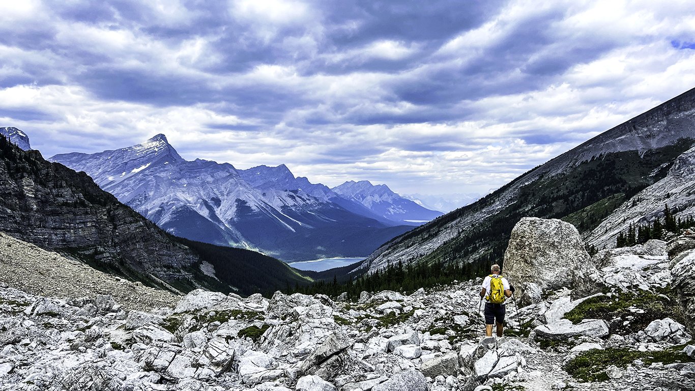
It was time. Two and a half years had passed since we traveled to our home away from home in the Canadian Rockies. With Covid running rampant and borders closed, everyone lived in isolation. Traveling was a risk, not an entitlement. So Dave and I (along with millions of others) buckled down and made the most of it. However, when the border opened last fall, there was no question about where we would spend our next summer.

Comment

Lookout Mountain Summit

Comment

Lookout Mountain Summit

Dave and I have stepped up our hiking regimen by hiking up North Mountain National Trail three times a week—in preparation for summer hikes in the Canadian Rockies. Short and steep, rocky yet also paved, and mercifully close to the house. From the top, we spotted Lookout Mountain, nestled behind a resort and golf course bearing the same name. That moment decided our next hike.

Comment

Pinnacle Peak Trail

Comment

Pinnacle Peak Trail

Pinnacle Peak Trail ranks high in everyone’s books. Locals and vacationers from nearby resorts flock to this place in droves—with good reason. It is an impeccable trail with fantastic views of the valley and surrounding McDowell Mountains.

Comment

Bushnell Tanks

Comment

Bushnell Tanks

Nestled within the Mazatzal mountains lies a lovely little hike that traverses along a rustic creek and an old ranch road to some ancient-looking water tanks. After reading about this hike in the Arizona Republic, Dave and I became intrigued. We’d driven the Beeline Highway between Mesa and Payson many times but never pulled off to discover what lay beyond it.

Comment

Dutchman’s Trail #104

Comment

Dutchman’s Trail #104

Sunrise in the Superstitions—hmmm, it sounds like a song title from the 70s. And to think this rugged wilderness is 45 minutes east of metro Phoenix—the Crown Jewel of Apache Junction.

Comment

Kachina Trail

Comment

Kachina Trail

We were looking for gold in a mountain town. When you live on the valley floor, it’s often difficult to gauge the right time to see fall colors. Sure, you can watch the predictions on the local news, but unless you live up north, it’s best to take a chance and go.

Comment

Morning Walks

1 Comment

Morning Walks

By September, memories of why we live here started to surface. An unexpected early taste of Fall arrived, and once again—we pulled on our hiking boots and stepped outside for some genuine morning walks.

1 Comment

A Canopy of Green

1 Comment

A Canopy of Green

Well, it's June, and still—no word. With the northern border closed, our home away from home was still elusively out of reach. Fully vaccinated, the longing to see family face to face became overwhelming. Add that to 115° temps—time leave town.

1 Comment

Neighborhood Bloom

Comment

Neighborhood Bloom

People trample over flowers, yet only to embrace a cactus.—James Joyce

Alas, there were no wildflowers this year. The heat and drought of the past summer eliminated any chance of an appearance. Happily, the cactus did not disappoint.

Comment

Quartz Ridge to Mohave Trail

1 Comment

Quartz Ridge to Mohave Trail

The days for hiking in the Phoenix Mountains are ticking down. Summer is rearing its ugly head, and as temperatures rise, the vibrance of spring quickly fades. Geez, how depressing is that?

1 Comment

Thunder Mountain Trail

Comment

Thunder Mountain Trail

With a little research and patience, it is possible to hike in Sedona and avoid the influx of visitors. Enter Thunder Mountain Trailhead, part of the North Urban Trail System in Sedona. The mission that day was a Birthday mission, one which Dave, Margaret, and I chose to accept.

Comment

Piestewa Peak

Comment

Piestewa Peak

Ahhh, Piestewa. Climbing the second highest peak (2,610 ft) in the Phoenix Mountains takes willpower—but to many, and I mean MANY, the hike is more than worth it. After all, how many places can one summit a mountain in the middle of a city?

Comment

Pioneer Trail 196

Comment

Pioneer Trail 196

Timing combined with a whole lot of luck. When that happens, it’s a beautiful thing to behold. On this particular hike, I believe the experience would not have been nearly as spectacular.

Comment